The north Travel Guide

The level expanses of northern Belize are a mixture of farmland and rainforest, dotted with swamps, savannas and lagoons. Most visitors come to the region for its Maya ruins and wildlife reserves. The largest Maya site, Lamanai, served by regular boat tours along the New River Lagoon, features some of the most impressive pyramids and beautiful scenery in the country. The site of Altun Ha, meanwhile, is usually visited on a day-trip from Belize City. The northern reserves also host an astonishingly diverse array of wildlife. At the Community Baboon Sanctuary, a group of farmers have combined agriculture with conservation to the benefit of the black howler monkey, and at the stunning Crooked Tree Wildlife Sanctuary, rivers and lagoons offer protection to a range of migratory birds.

Many of the original residents in this region were refugees from the nineteenth-century Caste Wars in Yucatán, and some of the northernmost towns are mainly Spanish-speaking. The largest settlement today is Orange Walk, the country’s main centre for sugar production. Further north, near the border with Mexico, Corozal is a small Caribbean town, strongly influenced by Maya and mestizo culture.

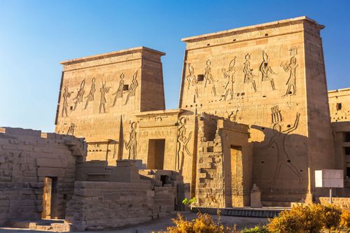
Top image: Lamanai archaeological reserve mayan Mast Temple in Belize jungle © Photo Spirit/Shutterstock

Altun Ha

Some 55km north of Belize City and just 9km from the sea is the remarkable Maya site of Altun Ha (daily 8am–5pm; Bz$10), which was occupied for twelve hundred years until it was abandoned around 900 AD. Its position close to the Caribbean suggests that it was sustained as much by trade as by agriculture – a theory upheld by the discovery here of obsidian and jade, neither of which occurs naturally in Belize.

Altun Ha clusters around two Classic-period plazas. Entering from the road, you come first to Plaza A, enclosed by large temples on all sides. A magnificent tomb was discovered beneath Temple A-1, the Temple of the Green Tomb. Dating from 550 AD, this yielded jades, jewellery, stingray spines, skin, flints and the remains of a Maya book. The adjacent Plaza B is dominated by the site’s largest temple, the Temple of the Masonry Altars. Several tombs have been uncovered within the main structure; in one, archeologists discovered a carved jade head of Kinich Ahau, the Maya sun god. Just under 15cm high, it is the largest carved jade found in the Maya world; a replica is on display in the Museum of Belize.

Outside these two main plazas are several other areas of interest, though little else has yet been restored. A short trail leads south to Rockstone Pond, a reservoir in Maya times, at the eastern edge of which stands another mid-sized temple. Built in the second century AD, this contained offerings from the great city of Teotihuacán in the Valley of Mexico.

Cerros

Built in a strategic position at the mouth of the New River, the late Preclassic centre of Cerros (daily 8am–5pm; Bz$10) was one of the first places in the Maya world to adopt the rule of kings. Despite this initial success, however, Cerros was abandoned by the Classic period. The ruins of the site now include three large acropolis structures, ball courts and plazas flanked by pyramids. The largest building is a 22m-high temple, whose intricate stucco masks represent the rising and setting sun.

A sporadic bus service runs from Corozal to the nearby village of Copper Bank, and from there it is possible to rent a bike to access the ruins (20min). However, the most comfortable and reliable way to reach the ruins is by boat. Hotels in Corozal can give advice on arranging a charter (ask at the Sea Breeze Hotel or Hok’ol K’in Guesthouse), which operate either with (from US$75 per person) or without (from US$30 per person) a guided tour. Visitors should note that mosquitoes around the site are particularly pesky – prepare accordingly.

Community Baboon Sanctuary

Heading north from Belize City, the Community Baboon Sanctuary (Bz$14; w www.howlermonkeys.org), to the west off the Northern Highway, is one of the most interesting conservation projects in Belize. It was established in 1985 by Dr Rob Horwich and a group of local farmers (with help from the World Wide Fund for Nature), who developed a code of conduct of sustainable living and farming practices. A mixture of farmland and broad-leaved forest along the banks of the Belize River, the sanctuary coordinates seven villages, of which Bermudian Landing is the most convenient, and more than a hundred landowners, in a project of conservation, education and tourism.

The main focus of attention is the black howler monkey (known locally as a “baboon”). These primates generally live in groups of between four and eight, and spend the day wandering through the canopy, feasting on leaves, flowers and fruits. At dawn and dusk they let rip with their famous howl: a deep and rasping roar that carries for miles. The sanctuary is also home to over two hundred bird species, as well as iguanas, peccaries and coatis. You can find exhibits and information on the riverside habitats and animals you are likely to see in the natural history museum – Belize’s first – at the reserve’s visitors’ centre in Bermudian Landing.

Corozal

South from the Mexican border, the road meets the sea at the town of Corozal, near the mouth of the New River. The ancient Maya prospered here by controlling river and seaborne trade, and the impressive site of Cerros is nearby, if complicated to reach. Present-day Corozal was founded in 1849 by refugees from Mexico’s Caste Wars, although today’s grid-pattern layout, a neat mix of Mexican and Caribbean, is largely due to reconstruction in the wake of Hurricane Janet in 1955.

There’s little reason to spend time in Corozal unless you are trying to get to Cerros. However, it is an ideal place for a few days of quiet relaxation. The breezy shoreline park is good for a stroll, while on the tree-shaded main plaza, the town hall is worth a look inside for a mural by Manuel Villamar Reyes, which vividly describes local history. In the block west of the plaza you can see the remains of Fort Barlee, built to ward off Maya attacks in the 1870s.

Santa Rita

The small Maya site of Santa Rita (open 24hr; free) is within walking distance of the centre, about 15 minutes northwest of town; follow the main road towards the border, bear right at the fork and turn left at the Super Santa Rita store. Though it is an interesting enough spot if you have time to kill, the site is no longer maintained and does not justify extending your stay in Corozal. Founded around 1500 BC, Santa Rita was in all probability the powerful Maya city later known as Chactemal. It was still a thriving settlement in 1531 AD, when the conquistador Alonso Davila entered the town, only to be driven out almost immediately by Na Chan Kan, the Maya chief, and his Spanish adviser Gonzalo Guerrero. The main remaining building is a small pyramid, and excavations here have uncovered the burial sites of an elaborately bejewelled elderly woman and a Classic-period warlord.

Crooked Tree Wildlife Sanctuary

Midway between Belize City and Orange Walk, a branch road heads west to Crooked Tree Wildlife Sanctuary (daily 8am–4.30pm; Bz$8), a reserve that encompasses swamps, wetlands and four separate lagoons. Designated Belize’s first Ramsar site (to protect wetlands of international importance), the sanctuary provides a resting place for thousands of migrating and resident birds, such as snail kites, tiger herons, snowy egrets, ospreys and black-collared hawks. The reserve’s most famous visitor is the jabiru stork, the largest flying bird in the New World, with a wingspan of 2.5m. The best months for birdwatching are late February to June, when the lagoons shrink to a string of pools, forcing wildlife to congregate for food and water.

In the middle of the reserve, straggling around the shores of a lagoon, is the village of Crooked Tree, which is linked to the mainland by a causeway. One of the oldest inland villages in the country, Crooked Tree is also one of Belize’s loveliest, with well-kept houses and lawns dotted along tree-lined lanes. Though guided tours to the lagoon are quite expensive (at least US$50–80), numerous trails, signposted from the roads, wind around the island and along the shoreline, where you’ll see plenty of birds and wildlife even without a guide.

Lamanai

Extensive restoration, a spacious museum and a stunning jungle setting make Lamanai (Mon–Fri 8am–5pm, Sat, Sun & holidays 8am–4pm; Bz$10) the most impressive Maya site in northern Belize. It is also one of the few sites whose original Maya name – Lama’an ayin (“Submerged Crocodile”) – is known, hence the numerous representations of crocodiles on stucco carvings and artefacts found here. Lamanai, however, is a seventeenth-century mis-transliteration, which actually means “Drowned Insect”. The site was continually occupied from around 1500 BC up until the sixteenth century, when Spanish missionaries built a church alongside to lure the Indians from their “heathen” ways.

Today the site is perched on a bank of the New River Lagoon inside a 950-acre archeological reserve, where the jungle surroundings give the site a feeling of tranquillity. Before heading to the ruins, visit the spacious new archeological museum, which houses an impressive collection of artefacts, eccentric flints and original stelae. Within the site itself, the most remarkable structure is the prosaically named N10-43 (informally the “High Temple”), a massive Late Preclassic temple over 37m tall and the largest from the period in the Maya region. The view across the surrounding forest and along the lagoon from the top of the temple is magnificent, and well worth the daunting climb. North from here is N9-56, a small sixth-century pyramid (often called the “Mask Temple”, for its exceptionally well-preserved 4m-high stucco mask of a ruler represented as a deity, probably Kinich Ahau, the sun god). At the southern end of the site, on a grand plaza, is another sixth-century pyramid, structure N10-9, known as the Jaguar Temple for the two large, stylized jaguar masks adorning its lowest level.

Orange Walk

Like many of Belize’s northern cities, Orange Walk, the largest town in the region, was founded by mestizo refugees fleeing the Caste Wars in the Yucatán. Long before their arrival, however, the area around Orange Walk had been worked as some of the most productive arable farmland in Belize – aerial surveys have revealed evidence of raised fields and a network of irrigation canals dating from ancient Maya times. Today, Orange Walk is a thriving community by Belizean standards, and though there aren’t any real attractions in the town itself, it’s a pleasant, low-key base for those looking to explore one of the region’s highlights: the nearby ruins at Lamanai.

At the centre of town is a distinctly Mexican-style formal plaza, and the town hall is referred to as the Palacio Municipal, reinforcing the town’s strong historical links to Mexico. The only real sight in town, per se, is the Banquitas House of Culture (Mon–Thurs 8.30am–5pm, Fri 8.30am–4.30pm; free; 322-0517, www.nichbelize.org), on the riverbank near the bridge, which houses a permanent exhibition charting the history of Orange Walk District from Maya times to the present.

The Mennonites

Members of Belize’s Mennonite community, easily recognizable in their denim dungarees, can be seen trading produce and buying supplies every day in Orange Walk and Belize City. The Mennonites, a Protestant group often noted for their pacifist beliefs and rejection of modern advancements, arose from the radical Anabaptist movement of the sixteenth century and are named after Dutch priest Menno Simons. Recurring government restrictions on their lifestyle, especially regarding their objection to military service, have forced them to move repeatedly over time. Having emigrated to Switzerland, they then travelled to Prussia, and in 1663 a group moved to North America. After World War I they migrated from Canada to Mexico, eventually arriving in Belize in 1958. In recent years, farm-produced prosperity has caused drastic changes in their lives: the Mennonite Church in Belize is increasingly split between a modernist section – who use electricity and power tools, and drive trucks, tractors and even cars – and the traditionalists, who prefer a stricter interpretation of beliefs.

Sarteneja and Shipstern Nature Reserve

Across Chetumal Bay from Corozal, the largely uninhabited Sarteneja peninsula is covered with dense forests and swamps that support an amazing array of wildlife. Sarteneja, the peninsula’s only settlement, is a peaceful, Spanish-speaking, lobster-fishing community that boasts several hotels and restaurants. Tourism is just beginning to take off in this quiet village but, unlike some parts of the country, the locals are keen to ensure that future development is carried out at a financially and environmentally sustainable level.

All buses to Sarteneja pass the entrance to Shipstern Nature Reserve (daily 8am–4pm; Bz$15; w rainforest.org), 5km before the village, though you can also get here by renting a bike from Fernando’s Guesthouse or Backpackers Paradise in Sarteneja. The reserve encompasses an area of eighty square kilometres, including large areas of tropical moist forest, some wide belts of savanna, and most of the shallow Shipstern Lagoon, dotted with mangrove islands. The visitors’ centre offers a variety of guided walks, though even if you choose the shortest, you’ll encounter more named plant species here than on any other trail in Belize. Shipstern is also a birdwatcher’s paradise: the lagoon system supports blue-winged teal, American coot and huge flocks of lesser scaup, while the forest is home to keel-billed toucans and at least five species of parrot. Other wildlife in the reserve includes crocodiles, jaguars, peccaries and an abundance of wonderful butterflies.

Planning your own trip? Prepare for your trip

Use Rough Guides' trusted partners for great rates

Rough Guides Editors

written by
Rough Guides Editors

updated 26.04.2021

Ready to travel and discover
Belize?

Get support from our local experts for
stress-free planning & worry-free travels

Plan my trip ⤍