Abergavenny and around
Flanking the Brecon Beacons National Park, Abergavenny (Y Fenni), seven miles southeast of Crickhowell, is a busy and breezy market town which people flock to primarily for its outstanding cuisine – this reaches its zenith during the September Food Festival.
The town is also a useful base for walkers bound for the local mountains: Sugar Loaf, the Blorenge, and the legend-infused Skirrid Mountain (Ysgyryd Fawr). Stretching north from town, the Vale of Ewyas runs along the foot of the Black Mountains, where the astounding churches at Partrishow and Cwmyoy are lost in rural isolation.
Abergavenny also makes a good base for visiting Monmouthshire’s “Three Castles”, set in the pastoral border country to the east.
The Black Mountains
The easternmost section of the national park centres on the Black Mountains, far quieter than the central belt of the Brecon Beacons and skirted by the wide valley of the River Usk to the south and the Wye to the north. The only exception to the Black Mountains’ unremitting sandstone is an isolated outcrop of limestone, long divorced from the southern belt, that peaks north of Crickhowell at Pen Cerrig-calch (2302ft).
The Black Mountains have the feel of a landscape only partly tamed by human habitation: tiny villages, isolated churches and delightful lanes are folded into an undulating green landscape that levels out to the south around the village of Crickhowell.
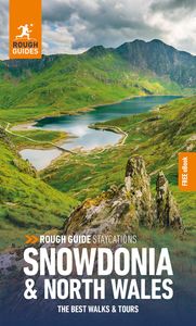
Brecon and the Brecon Beacons
Brecon (Aberhonddu) is a handsome county town at the northern edge of the central Beacons. The proliferation of Georgian buildings and its proximity to the hills and lakes of the national park make it a popular stopping-off place and a good base for day-walks in the well-waymarked hills to the south.
Popular for walking and pony trekking, the central Brecon Beacons, grouped around the two highest peaks in the national park, are easily accessible from Brecon, which lies just six miles to the north. The panorama fans out from the Brecon Beacons Mountain Centre, on a windy ridge just off the A470 turn-off at Libanus, six miles southwest of Brecon. As well as a fantastic café, there are displays on the area and a well-stocked shop. Pen y Fan (2907ft) is the highest peak in the Beacons. Together with Corn Du (2863ft), half a mile to the west, they form the most popular ascents in the park.
Hay-on-Wye
Straddling the Anglo-Welsh border some twenty miles west of Hereford, the hilly little town of Hay-on-Wye has an attractive riverside setting and narrow, winding streets lined with an engaging assortment of old stone houses, but is known to most people for one thing – books.
Hay saw its first bookshop open in 1961; today just about every inch of the town is given over to the trade, including the old cinema and the ramshackle stone castle. The prestigious Hay Festival of literature and the arts, is held over ten days at the end of May, when London’s literary world decamps here en masse.
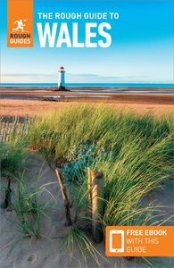
For more information and inspiration for travelling in Wales and the The Brecon Beacons National Park, check out the Rough Guides to Wales, as well as the best travel experiences in Wales, the best beaches in Wales, full guide to Snowdonia National Park, these beautiful pictures of North Wales and the best walks and hikes.