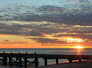
Broome
“Slip into Broometime” is a well-worn aphorism that captures the tropical charm of BROOME, clinging to the peninsula overhanging Roebuck Bay. This is the western reach of the rugged and remote Kimberley and despite Broome’s numerous tourist facilities something of a “Wild West” air prevails. It’s a good 2000km from here to the nearest city of any size and the town has more in common with the deepest Outback than it does with downtown Perth.
Broome began its life as a pearling town. Easily collected pearl shell heaped along nearby Eighty Mile Beach led to the northwestern “pearl rush” of the 1880s, initially enabled by the enslaved Aborigines. Later, indentured workers from Asia sought the shell in ever-greater depths below the waves, and Broome originated as a camp on sheltered Roebuck Bay where the pearl luggers laid up during the cyclone season.
After a violent and raucous beginning, the port finally achieved prosperity thanks to the nacre-lined oyster shells, or mother-of-pearl. By 1910, eighty percent of the world’s pearl shell came from Broome, and a rich ethnic mix and a rigidly racially stratified society had developed. Each season one in five divers died, several more became paralyzed and, as Broome’s cemeteries steadily filled, only one shell in five thousand produced a perfect example of the silvery pearls unique to this area.
Stagnation then rebuilding followed both world wars, after the second of which the Japanese – masters in the secret art of pearl culturing – warily returned and invested in pearl-farming ventures. Things improved with the sealing of the coastal highway from Perth in the early 1980s and the philanthropic interest of English businessman Alistair McAlpine, who led the old town’s tasteful development and refurbishment, using its oriental mystique and pearling history as inspiration. Today a mining boom is well underway and Broome is expected to double in population in the next twenty years.
The Gibb River Road and the northern Kimberley
To cross the expansive northern Kimberley, the alternative to the quick yet uninspiring Great Northern Highway is the epic Gibb River Road (GRR). Originally built to transport beef out of the central Kimberley cattle stations to Wyndham and Derby, the “Gibb” cuts through the region’s heart, offering a vivid slice of this vast and rugged expanse. It’s 670km from its western end just south of Derby to its eastern end between Kununurra and Wyndham, 230km shorter than the Great Northern Highway. Although some people have mistaken it as such, the Gibb is no short cut, with corrugations and punctures guaranteed – heed the advice on off-highway driving (see Roads, Outback driving and breakdowns). Accessed from the Gibb, the even more remote Kalumburu Road leads to the increasingly popular Mitchell River National Park.
As a scenic drive in itself the Gibb is very satisfying, but it’s the wayside attractions that make this route what it is – the homesteads, gorges and pools here are almost uniformly spectacular, and offer a real glimpse of Outback Australia. A comprehensive and annually updated Travellers Guide to the Inland Kimberley and Mitchell Plateau ($5) is available at local visitor centres and is worth picking up.
If you’re traversing the GRR west to east and want to spare your car the full ordeal, turn back at Manning Gorge and head down to the highway via Windjana Gorge – the best and most accessible gorges are along the western half of the GRR. If you just want a taste of the Gibb, it’s possible to visit Windjana Gorge and Tunnel Creek national parks in a day from Derby or Fitzroy Crossing; this snippet is just about doable in a solid 2WD in the Dry. Otherwise, a sturdy 4WD that you know how to maintain is a must – at the very least carry two spare tyres.
Windjana Gorge National Park
- 21km south of the Gibb River Rd
- DPaW fee
- w dpaw.wa.gov.au
A turn-off south from the Gibb River Road, 124km from Derby, leads to the towering ramparts of Windjana Gorge. Much of the landscape here and around Tunnel Creek are the remnants of the Devonian Reef, a large barrier reef that grew around the then-submerged Kimberley plateau 350 million years ago. A walking trail leads into the spectacular gorge, where freshwater crocodiles sun themselves in the afternoon at a small permanent pool, and fruit-bat-filled paperbark and Leichhardt trees line the riverbanks. Look out also for the striped archer fish, which kills insects by spitting jets of water at them. Three kilometres east of the gorge are the ruins of Lillimooloora Police Station, where a Constable Richardson died after an altercation with his Aboriginal tracker Jandamarra or “Pigeon”.
It’s a further 37km south of Windjana Gorge to fun Tunnel Creek National Park, where the creek has burrowed its way under the range, creating a 750m tunnel hung with fruit bats. Although the collapsed roof illuminates the cavern halfway, the wade through the progressively deeper and colder water to the other end still takes some nerve, especially with the golden eyes of freshwater crocs following your progress from the side of the pool – they shouldn’t bother you, though. You’ll need a torch and sturdy shoes that you don’t mind getting soaked. Moving into the Wet, around November, check weather conditions at Fitzroy Crossing, as the tunnel can fill quickly if the Fitzroy River receives a lot of water.
The western Gibb River Road
The GRR winds its way through the impressive King Leopold and Napier ranges in the King Leopold Ranges Conservation Park (DPaW fee), passing, at 133km from Derby, a famous rock bearing more than a little resemblance to Queen Victoria.
At 196km is the access road for Lennard River Gorge, a dramatic cleft carved through tiers of tilted rock, just 8km south of the GRR in the middle of the King Leopold Ranges. You may find it quicker to walk the last 2km, which are very rough in parts. At 219km is the access track north to popular Bell Gorge (29km from the GRR; $10 per vehicle entrance fee). This is the loveliest gorge along the GRR, with a pretty swimming hole, and there’s camping at Silent Grove.
Back on the GRR, the Imintji Store is 227km from Derby (daily 7am–5pm; t 08 9191 7471), and sells diesel fuel only, ice and a good supply of groceries, as well as carrying out basic vehicle repairs. Continuing on, 253km from Derby, a long 82km detour south over some creeks brings you to enjoyable Mornington Wilderness Camp. From here, you can access the impressive Sir John Gorge, which has broad pools ideal for swimming; exploring upstream leads you to even greater grandeur.
Charnley River Station is 43km north of the GRR, 257km along the road from Derby. Continuing down the GRR for 35km you reach Galvans Gorge (700m), the most accessible of all the GRR’s gorges.
At 305km, Mount Barnett Roadhouse serves food and carries fuel and some supplies. Camping is permitted behind the roadhouse by Manning River, where a 5km trail leads to Manning Gorge, with a large swimming hole and a pretty waterfall. Another 29km down the GRR is Barnett River Gorge (5km north of GRR), with swimming in a billabong.
At 340km from Derby and 365km from Kununurra Mount Elizabeth Station is about halfway along the GRR, about 30km north, and offers accommodation. At 406km you reach the turn-off for the Kalumburu Road before crossing the Durack River.
The Northern Kimberley: up Kalumburu Road
Though a common-enough destination in the Dry, the Northern Kimberley is a very remote region where a well-equipped 4WD and Outback skills are essential.
Heading north at the Kalumburu Road junction, midway along the Gibb River Road, after 59km you’ll come to Drysdale River Station which has accommodation and fuel (no LPG). The beautiful, four-tiered Mitchell Falls, on the Mitchell Plateau, are the main attraction here, and the reason most people take on the Kalumburu Road – this once remote spot is getting less so by the year and is now a national park.
Take the left turn-off from the Kalumburu Road, 160km north of the GRR, and head 80km west over King Edward River to the falls; the turn-off is extremely rough and takes up to four hours one-way. From the Mitchell Falls car park it’s a tough 3km walk (4–6hr return) northwest to the falls themselves (passing Little and Big Merten’s Falls on the way). You can swim in the upper pools of the main falls, or arrange a scenic flight or a six-minute lift back to the car park via helicopter with Slingair.
Kalumburu
Continuing along the Kalumburu Road from the Mitchell Falls turn-off, 267km after the GRR junction is Kalumburu, an Aboriginal community with the languorous feel of an African village. As well as being able to get (expensive) fuel and basics at the store here (t 08 9161 4333; Mon–Fri 7.30–11.30am & 1.30–4pm), you can visit the mission (Tues, Thurs & Fri 8.30am–10.30am; $10) set up in the nineteenth century by Benedictine monks. Kalumburu is a completely dry community, so don’t even BYO alcohol.
The eastern Gibb River Road
The eastern section of the Gibb River Road has less to detain you than the western section, but more options for stopovers, with a range of homesteads and stations offering accommodation and activities.
There are a few places worth stopping on Home Valley Station, which is half the size of Belgium and runs both sides of the GRR. At 627km from Derby the Bindoola Falls Trail is an easy stroll to a lookout over the rugged cliff edge to the falls beyond; at 642km pull off into the lookout area for panoramic views of the Cockburn Ranges, Cambridge Gulf and Pentecost River. At 643km (and just 120km from Kununurra) is the Home Valley Station homestead itself, with accommodation, horseriding, cattle mustering, hikes, fishing and station tours.
After another 9km you will cross the Pentecost River, an experience in itself as you grit your teeth and drive headlong through the waters, knowing that saltwater crocs lurk nearby. Crossing this feels a little like crossing the finish line, with just 24km remaining between you and the bitumen, at 626km and the turn-off for El Questro Wilderness Park (25km south of the GRR), where you’ll find both luxury accommodation and campsites and a range of tours including barramundi fishing, horse trekking and helicopter flights.
Don’t miss a final stop at Emma Gorge. Argued by many to be the GRR’s most beautiful gorge, it is all dripping palm fronds, deep red cliffs and water holes along the 1.6km trail to a glorious swimming hole and waterfall. There are no crocs here and there are few more picturesque places for a dip. Allow two hours for the return hike, including a swim, and wear sturdy shoes.
From here it is a further 23km to the Great Northern Highway junction; turn right for Kununurra (52km) or left for Wyndham (48km).
Accommodation and eating
Camping is only allowed in designated campsites, and camping fees of around $10 per person always apply. All campsites have bush toilets, drinking water and showers – some also have gas barbecues and other facilities. Many roads, gorges, services and accommodation are closed in the Wet from around November to March – always check conditions and opening dates before you set out and book accommodation in advance where possible. It’s best to visit at the start of the Dry, when the land is lush from the rains and rivers are full.
Driving the Gibb River Road
Travelling along the Gibb River Road is not as strenuous as you may have been led to believe, but is still not to be undertaken lightly. Don’t even think about attempting it in anything less than a sturdy 4WD and make sure you have enough food and water for several extra days, and around twenty litres of spare fuel, in case of emergencies. Some basic mechanical knowledge will get you a long way, but in the event of a breakdown everybody will stop to help and a real sense of camaraderie exists as you make your way along this popular route with the other travellers hardy enough to have embarked on this adventure without a tour guide. Driving up the Kalumburu Road requires some 4WD experience and should only be attempted by the confident.
Indigenous history in northern WA
The history of Aboriginal people in Australia’s northwest differs greatly from those on the east coast or in southern WA due to a colonial quirk. The British Colonial Secretaries Office decreed in 1865 that due to the extreme heat no convict labour was to be used further north than the 26th parallel. Consequently, rather than being slaughtered as on the east coast, local indigenous people were pressed into service in the burgeoning pastoral and pearling industries, meaning that their white “owners” were paradoxically depleting their workforces whenever they wanted to imprison local Aborigines for minor offences (an unsurprisingly regular occurrence).
The story of Jandamarra or “Pigeon” gives an interesting perspective on relations between Aborigines and white settlers. Jandamarra, a member of the Bunuba group, was made a “tracker” in the 1890s, and was expected to work with the white police force to weed out Aboriginal criminals. When rounding up a group of such “criminals” at Lillimooloora Police Station in 1894, Jandamarra’s loyalties to his people returned to the fore, and he killed a policeman, Constable Richardson, instigating a three-year “war” between his followers and the police force. His escapes from Windjana Gorge and Tunnel Creek entered folklore – in the latter case the police staked out one end of the tunnel for days, in the belief that it was a cave, while Jandamarra escaped from the other end. Ironically, it was another Aboriginal tracker who caught and shot Jandamarra at Tunnel Creek in 1897.
By the 1880s, huge numbers of Aboriginal people were “black-birded”, or uprooted from their traditional communities, and marched for hundreds of kilometres to pastoral or pearling stations. With pastoralism dominating the area’s economy for the next hundred years, it took a shamefully long time for the mistreatment of indigenous workers to end, and it was only in 1966 that equal pay was granted to Aboriginal stockmen and farm workers. Unfortunately, this did not bring an end to Aboriginal suffering, as the increased mechanization of the farming industry resulted in the now-unwanted labourers being driven off the stations and into towns far away from their traditional land.
Today, the harsh realities of indigenous life are displayed at every turn in the Kimberley, particularly in towns along the highway such as Halls Creek and Fitzroy Crossing. On a more positive note, Aboriginal art is a growing force across the region, bringing funds in to poor communities and in some cases alleviating social problems. The galleries and workshops in Roebourne and Kununurra are well worth a visit.
Lake Argyle
Thirty-five kilometres east of Kununurra on the Victoria Highway, a sealed road of the same distance leads to vast, scenic Lake Argyle. When the Argyle Dam was completed in 1972, the Ord River managed to fill the lake in just one wet season. Along with the neighbouring Victoria and the Fitzroy, these rivers account for a third of Australia’s fresh water run-off and plans are often mooted to pipe it south where it’s needed. Creating the lake was an engineer’s dream: only a small defile needed damming to back up a shallow lake covering up to two thousand square kilometres. Since that time the fish population has grown to support commercial fishing, as well as numerous birds and crocodiles, both saltwater and freshwater.